The Shawford Serendipity Trail
Table of Contents
The Shawford Serendipity Trail
A beginner’s guide through a historical treasure-hunt in Compton and Shawford, described by Tom Threlfall, who relied upon much original research by the late Barrie Hazlitt.
Tom also took most of the photos
Introduction
Waypoints shown on the map are indicated in the text by numbered markers, for example: ![]()
You can also download the Serendipity Trail 1997 as a printable file – but be warned that some transport and contact details are out of date.
The Itchen is not one of Britain’s longer rivers – its total length from the source near Cheriton to the sea is less than 25 miles – but man has left his footprints along the Itchen Valley quite abundantly ever since the Mesolithic hunters and fishermen ambled this way from the Mediterranean shores as the last Ice-age ended nearly 8000 years ago.
With much of what is now the sea locked into polar icecaps at that time the sea level was much lower than it is now, and these early visitors could walk across from France to arrive in the Selsey Bill area.
The Romans later (43AD) felt obliged to invade and colonise this part of Britain; they built a strategic road from Clausentum (Bitterne) to Venta Belgarum (Winchester) which ran south-north through the Parish of Compton & Shawford (C&S) some 3 miles south of Venta, with a road going off Southwest to Onna (Nursling) from Otterbourne – which is a mile or so south of Shawford.
Thus the parish of C&S makes a very satisfactory base from which to take a look at some of the more interesting pieces of flotsam which the tide of history has generously placed along and around the valley. Other parishes have their nature trails, but the animals and plants in the (C&S) area are quite similar to those found in adjacent Hampshire villages. C&S has its own unique local heritage, however, and if you have taken the trouble to visit this patch you should not leave until you have had a good look at some of the local sites and relics which associate it so closely with the nation’s history.
The Serendipity Trail will take just under a couple of hours to negotiate, but there are some short cuts (which will be indicated in the text) you could take which would reduce the time to about 50 minutes.
Sheet 185 of the Ordnance Survey “Landranger” series, or sheet 132 of the “Explorer” series would make interesting companions on your walk, but are by no means vital to your survival.
If the ground is damp you should wear a pair of stout walking shoes or boots. (webmaster’s note January 2014: map references updated – see Ordnance Survey Leisure maps page)
Your Trail may well start from the railway station, in which case you should turn right out of the building, pass the dormant shops on your right and the Bridge Hotel on the left, cross the Itchen Navigation by the road-bridge, and immediately cross the road and turn left (=north) up the towpath![]() .
.
The Bridge Hotel
If you left your car in the car park at the foot of Shawford Down you can go downhill to the bridge and join the trail here. If you used the Bridge Hotel car park you were more or less obliged to pass through the bar on your way to the river bridge, and it would have been wise to take some oral rehydration therapy if the day looked likely to be a warm one.
It was at the shallow ford (= Shawford) here that Charles II crossed the river on his way to sanctuary on the Continent, having heavily lost the Battle of Worcester in 1651.
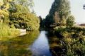
Walk up the riverbank![]() some 500 yds to Compton Lock,enjoying glimpses of the very handsome church at Twyford (=two fords) over to your right, and then turn left (=west) off the towpath to cross the mouth of the lock chamber using the footbridge.
some 500 yds to Compton Lock,enjoying glimpses of the very handsome church at Twyford (=two fords) over to your right, and then turn left (=west) off the towpath to cross the mouth of the lock chamber using the footbridge.
![]() The lock forms part of a canal from Alresford to Southampton, opened to traffic in 1710. It served well and prospered during the Napoleonic wars, which ended with Waterloo in 1815.
The lock forms part of a canal from Alresford to Southampton, opened to traffic in 1710. It served well and prospered during the Napoleonic wars, which ended with Waterloo in 1815.
The railway under which you will shortly pass (and which also terminates at Waterloo) was built in 1837, and took the canal’s business away; the last canal cargo was carried in 1869. Shawford station opened to traffic on 1st September 1882.
Continuing westwards you cross an Itchen feeder by a footbridge, and traverse some 200yds of sometimes soggy woodland to cross the Bishop’s Drain – an insignificant little ditch which flows directly from Wolvesey Palace, on the south side of Winchester, to enter the Itchen Navigation on the south side of Shawford. It has no purpose apart from that implied by its name.
![]() Immediately after passing under the railway, some 300yds from Compton Lock, Red Lane joins your route from the left.
Immediately after passing under the railway, some 300yds from Compton Lock, Red Lane joins your route from the left.
Red Lane
Tradition has it that the corpse of William Rufus, who met his end in a New Forest hunting incident on 2nd August 1100, was brought this way in a charcoal-burner’s cart to Winchester Cathedral, and dripped its blood along the route.
The architect of Rufus’s demise was alleged to be Walter Tyrrel, who fled the country before he could be arrested; but Ralph of Aix was also accused whilst Tyrrel, from a safe distance, protested his innocence.
There was no doubt, however, that Rufus was a most unsavoury character – bull necked, florid, tubby, and fitted with a very short fuse. He died unmarried and without issue.
Goldfinch Cottage
![]() You now pass through a truck-sized tunnel under the M3 and enter Place Lane where you will find the Manor House and Goldfinch Cottage on your right, just before you cross the Winchester to Southampton main road – the Roman Road from Clausentum mentioned earlier.
You now pass through a truck-sized tunnel under the M3 and enter Place Lane where you will find the Manor House and Goldfinch Cottage on your right, just before you cross the Winchester to Southampton main road – the Roman Road from Clausentum mentioned earlier.
Whilst Oliver Cromwell was laying siege to Winchester in 1643 one of his officers – a Captain Barnard – called with his troop at Goldfinch Cottage to request food and lodging for the night from the Goldfinches.
![]() The householder was not too pleased, since his own wife was about to give birth, and any available food and drink was to be used to celebrate that event – but he gave permission for the troop to sleep in the barn if they wished.
The householder was not too pleased, since his own wife was about to give birth, and any available food and drink was to be used to celebrate that event – but he gave permission for the troop to sleep in the barn if they wished.
Barnard promised that he and his men would be no trouble, and asked that if the child should be a boy perhaps he might be christened Barnard?
A boy was duly born, and Barnard Goldfinch was buried 75 years later in Compton churchyard.
Cross the main road into Compton Street – the name derives from “Coombe Tun”, the Saxon phrase for a hamlet in a valley.
All Saints’ Church
![]() All Saints church (on the left) some 200 yds from the main road, would make you welcome, provided your boots were not dripping mud. It is of Saxon origin, but with a Norman doorway in the north porch, and many Norman features inside.
All Saints church (on the left) some 200 yds from the main road, would make you welcome, provided your boots were not dripping mud. It is of Saxon origin, but with a Norman doorway in the north porch, and many Norman features inside.
Immediately after the church turn left (=south) down Carman’s Lane, and ![]() follow the path to the right where it climbs between high banks and yew trees to join Hurdle Way.
follow the path to the right where it climbs between high banks and yew trees to join Hurdle Way.
Yew tree walk
The evergreen yew is a symbol of immortality, and was popular in earlier years as a means of improving a traveller’s morale in spots where he might otherwise have felt nervous; crossing large tracts of open countryside did indeed make travellers nervous.
Wolves and highwaymen were excellent reasons for our predecessors to have some severe reservations about travelling, particularly when there was an “R” in the month.
Hundred percent waterproof footwear is a very recent blessing to the human race, and the vulcanised rubber so vital to the “Wellington” boot was not available commercially until well into the 18th Century.
If you have had enough walking now, you can turn left along Hurdle Way, take the bridge over the M3, enter Shawford Down at the gate by the southbound bus stop, and rejoin the itinerary at (![]() ,
,![]() or
or![]() ) to find your train or your car.
) to find your train or your car.
For a slightly longer shortcut, a short way east along Hurdle Way, turn right up Field Way, cross the Playing Field and pick up the walk on Shepherds Lane just before the tunnel under the M3.
Hurdle Way
If, however, you feel you could manage another hour or so, you can turn right (=west) and continue your walk with a fine view of Compton Street down to your right.
![]() Some 400yds after you joined Hurdle Way you may take a track slightly uphill to the left (=south) for about 1000 yards to join Shepherd’s Lane (at
Some 400yds after you joined Hurdle Way you may take a track slightly uphill to the left (=south) for about 1000 yards to join Shepherd’s Lane (at ![]() in the itinerary) where you turn left (=east) again to head back for Shawford which you will reach about one hour after you left it.
in the itinerary) where you turn left (=east) again to head back for Shawford which you will reach about one hour after you left it.
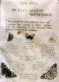
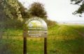
Yew Hill Butterfly Reserve
If, however, you feel enthusiastic enough to tackle the full circuit, keep on Hurdle Way ![]() heading west until you reach Yew Hill butterfly reserve
heading west until you reach Yew Hill butterfly reserve![]() , which is well advertised when you get there.
, which is well advertised when you get there.
It contains 31 species of butterfly, and 3 species of an orchid which the insects find particularly delicious.
Silkstead
You will note a Celtic trackway (Whitechute Lane) going off to the right (=north) here, but you turn left ![]() along Silkstead Lane and
along Silkstead Lane and ![]() continue in a southwesterly direction for just over a mile to
continue in a southwesterly direction for just over a mile to ![]() Silkstead itself, a hamlet at the southwest corner of the parish, and reputedly another request-stop on the late but unlamented William Rufus’s involuntary posthumous ride to Winchester Cathedral.
Silkstead itself, a hamlet at the southwest corner of the parish, and reputedly another request-stop on the late but unlamented William Rufus’s involuntary posthumous ride to Winchester Cathedral.
![]() The farmstead was the 13th century brainchild of a Prior Silkstede, of St Swithun’s monastery in Winchester, who used its produce to nourish his monks.
The farmstead was the 13th century brainchild of a Prior Silkstede, of St Swithun’s monastery in Winchester, who used its produce to nourish his monks.
You are well over half-way along the Serendipity Trail here; ![]() turn left to leave all the buildings on your right, and follow Shepherd’s Lane to the northeast.
turn left to leave all the buildings on your right, and follow Shepherd’s Lane to the northeast.
Some 800 yds from Silkstead the lane turns right to head east ![]() and it is here that you would have arrived had you taken the shortcut from Hurdle Way earlier in the walk.
and it is here that you would have arrived had you taken the shortcut from Hurdle Way earlier in the walk.![]() ,
,![]()
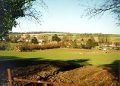
Shawford Down
At the east end of Shepherd’s Lane, where you would be joined by refugees from the first stage of the route (![]() ) you can pass beneath the M3 by means of a people-sized tunnel, then cross the Clausentum road once again before entering Southdown Road.
) you can pass beneath the M3 by means of a people-sized tunnel, then cross the Clausentum road once again before entering Southdown Road.
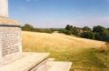
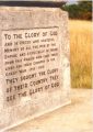
Shortly after moving on to the down you will see a granite war memorial, overlooking the Itchen valley.![]()
There is also a wooden cross (the Wayside Cross) ![]() on the west side of the down, commemorating the troops who marched this way en-route to Flanders in 1914.
on the west side of the down, commemorating the troops who marched this way en-route to Flanders in 1914.
At the top of Shawford Down you could rest to enjoy the view from the Beryl Croker Centenary seat and should now be able to orientate yourself to take whichever route you choose back from C&S to the real world.
Shawford Station
The trains from Shawford tend to go south at 54 minutes past each hour, and north at 19 minutes past; different at peak hours and on Sundays.
Before you leave the Down, spare a thought for the Celts, Druids, Romans, Danes, the French and our very own Department of Transport – each of whom has made some significant input into the vista which you are presently enjoying.
Come to enjoy it again soon.
TJT 10-96
Pictures of the route